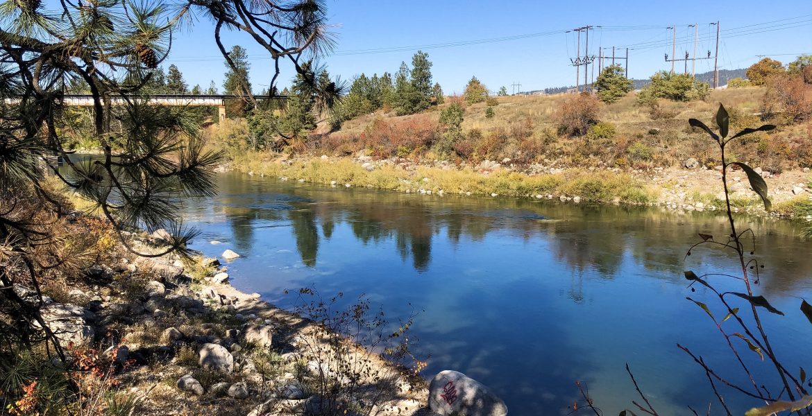
Run the Spokane River
#PNW . Travel . United States . WashingtonContents of this Post
Spokane Valley and the Centennial Trail Spokane
The Idaho – Washington Centennial Trail provides the best route to run the Spokane River. Run anywhere from the Spokane Riverfront Park to Spokane Valley, Coeur d’Alene, and more.

Run the Spokane River
Centennial Trail Spokane
Centennial Trail Map
Looking for an easy-to-use PDF map of the Washington Centennial Trail Spokane? Spokane County maintains a trail maintenance map throughout the county. The county map shows each of the segments in Spokane, Spokane Valley, and Liberty Lake. Click here to view the county’s PDF map, or explore the map below.

Centennial Trail Access Point: Spokane Valley, Washington
I spend quite a bit of time in Coeur d’Alene, Idaho (CDA), and Spokane, Washington for work. If I’m not staying in CDA, my go-to is the Hampton Inn and Suites in Spokane Valley. The hotel sits near Sullivan Road and the Spokane River. Sometimes hotel prices spike, or I want to be closer to the Spokane International Airport for an early morning flight. If you’re driving between Spokane and Coeur d’Alene, it’s easy to speed past the oversized commercial developments around the Spokane Valley Mall. But if you look a little closer, you’ll discover the Spokane River just across from the Hampton Inn. The well-developed Centennial Trail and Spokane River Water Trail sits nearby. The Spokane Centennial Trail contains a wide, paved path for walking, running, and biking. Unofficial gravel and dirt paths run parallel to the paved trail.

Centennial Trail Access Point: Mile Markers 9 to 11
If you’re looking for a place to stay and run the Spokane River, I recommend the stretch of the Centennial trail between mile markers 9 and 11. This section runs from the Spokane Valley Hampton Inn and Suites to Mirabeau Park and back (or vice-versa). As you’ll see below, the trail is accessible and follows the Spokane River East and West. Surrounded by lush growth and just over a small rise that separates the trail from the commercial development of Spokane Valley, the Centennial Trail feels far more remote and isolated than it is. Aside from the occasional peek at the industrial facilities across the river, the Spokane River Water Trail is a natural escape from the busy development along the freeway that runs between Spokane and North Idaho.

Planning to run the Spokane River soon? Click either of our banner links here to get discounted Hertz car rentals from the Spokane International Airport. Book rooms at the Spokane Valley Hampton Inn and Suites, and more! Our site is partly supported by affiliate partnerships; your purchases through our affiliate links help support our site and the development of even more great content!
Centennial Trail Spokane
Bridges and Scenery Along the Spokane River

Sullivan Road Bridge
To get to the Centennial Trail from the Spokane Valley Hampton Inn and Suites, just cross E. Indiana Avenue past the multi-story professional complex that sits opposite the hotel. At the far West end of the complex, just past the parking structure, you’ll find an access path that leads to the Centennial Trail. This section of trail overlooks the river around mile marker 11 of the trail. Head West along the path, and you’ll quickly arrive at the first of two bridges that cross the Spokane River before intersecting further North. The first bridge you’ll come to is the Sullivan Road vehicle bridge at Sullivan Park.
Indiana Avenue Train Bridge
About 1/2 mile further West, you’ll run underneath the second structure. This second bridge is a train bridge that runs along Indiana Avenue. It then crosses the Spokane River and continues under the vehicle overpass on Sullivan Road. Both bridges have a bit of graffiti painted on them. The city erected protective fences and barbed wire to keep would-be taggers from spraying more paint. It also limits their ability to cross the high, suspended tubes that run underneath the train tracks.


Mirabeau Park and the Spokane River Water Trail

Mirabeau Park Interpretive Signs and Centennial Trail Maps
Right at the 2 mile mark on my route, you’ll approach the Mirabeau Park and trailhead. Mirabeau Park is well-tended and inviting. It sits across from river access paths that lead down to large slabs of striated rock at the river’s edge. Centennial trail markers line the path leading to several interpretive signs and maps of the entire area. The signs mark the Spokane River Water Trail, the nearby section of the Centennial Trail through Spokane Valley. This is a great spot to stop and stretch, or take in the views of the river down below.

Centennial Trail Spokane: Run to the Spokane Riverfront Park
For added mileage, keep heading West; the trail continues for miles into Spokane’s city center. You can get whatever mileage you’d like and stay along the river the entire way. If you prefer trail running instead of a hard, paved path, the entire section between mile markers 9 and 11 has parallel dirt and gravel paths. Users have developed these over time, and the county and cities do not maintain the dirt paths. But I ran almost the entire 2 miles back to the East off the paved path on the elevated dirt trail. The parallel trail winds up and down and back and forth along the slight rise. It continues along a hill that separates the trail from Indiana Avenue.


Recreation and Restoration Along the Spokane River

Spokane River Fishing: Restrictions and Native Redrand Trout
The Spokane River flows from Lake Coeur d’Alene through Liberty Lake, Spokane Valley, Spokane. It eventually runs through the Spokane Indian Reservation and Lake Roosevelt. Fishing is allowed along most of the Spokane River. However, several sections have restrictions in place to assist the recovery of native Redrand Trout. You can catch non-native trout there, but Redrand must be released.
Spokane River Fishing: Catch and Release, Other Limits
So, for instance, from the Idaho border to the Upriver Dam in Spokane Valley, no fish may be caught and kept. You must release all fish in that section of river. Between the Upriver Dam and the Nine Mile Dam past Spokane, though, fishing is allowed, but limited. The length of my recommended run fits within the catch and release section of the Spokane River. That means you have all the more reason to spend your time running or walking the trail rather than fishing, at least until you make it past Spokane or back into Idaho!

Spokane Valley Hotels
The Spokane Valley Hampton Inn and Suites

Spokane Valley Hotels: Access and Accommodations
I’ve run along this section of trail for various distances over the last several years. I’ve run it in every season and type of weather. In my opinion, the Spokane Valley Hampton Inn and Suites by Hilton provides the best access points and area accommodations. The comfortable and reasonably priced hotel is just a short walk from the Centennial Trail. It sits just off the freeway past the Spokane Valley Mall on East Indiana Avenue.
Spokane Valley Hotels: Nearby Amenities
Nearby shops and restaurants make this the perfect spot to stay a night or two between Spokane and Coeur d’Alene. This is especially true if you’re planning to spend time in both cities. The hotel sits almost equidistant between the two towns. If you need to get back and forth quickly and easily, this is a great mid-way point for your stay. (The Hampton Inn and Suites in Coeur d’Alene sits on the Centennial Trail, as well. The CDA hotel sits in a newly-developed residential and commercial area. It is not far from North Idaho College and the lake, so that’s where I stay and run in CDA).






Looks like a great little trail to run along! I’m always happy to find an established trail when I’m traveling as it makes figuring out the mileage that much easier. I’m fortunate to have one near my house that runs through three cities in the South Bay Area. If I ever find myself in that Spokane area, this is definitely the trail I’ll seek out!
Love that there are so many great running spots in Spokane! I’m quite close (Vancouver, BC) so if I’m ever down in Spokane I would love to try out this trail. Looks very well maintained 🙂
It’s great that Spokane County provide a user-friendly map or anyone wanting to run the trail. And I can see that the trail is also very well maintained, so a great surface for runners. I love that photo of a train bridge crossing above the trail, with a little roofed hut beneath! The views are glorious.
Thanks, Kavita! They really do take great care of the trail, and there’s lots to see along the river. There are some great paths down to the river, too.
This looks like such an amazing trail! Nice too that it’s not so offbeat to get lost on.
Never heard of this trail before but it certainly looks amazing, the pictures make me want to travel and discover more. Your insight is very detailed and some of the photos really good too!
Looks like a fantastic running trail. The scenery is beautiful.
Wow, that looks like such a beautiful and diverse trail. And your guide is amazingly complete. After reading this, I could probably follow blindfolded 🙂
This looks like a great trail! Think it would be a bit long for me, do many people walk it or bike it instead?
It is a great trail, and well maintained! There are lots of bikers and walkers along the trail. It is definitely multi-use.
If I’m running, then you probably should be too 😉 Though this looks like a great place for an outdoor walk as well. Do they allow bikes? The trails look a bit narrow for both runners and bikers.
Thanks Pam! Yes, it’s definitely time for another run! The path is actually wide enough for bikes and runners, and you can run along the dirt paths and trails, too, for some variety. I know some people prefer trails to the hard, paved paths, so it’s nice to have both options here.
I never knew this was in Washington. It’s probably the perfect place for some outside time right now.