Oregon Hikes – Opal Creek Hike
#PNW . Hiking . Oregon . Outdoor Recreation . Travel . United States
Contents of this Post
The Best Oregon Hikes
Opal Creek and the Opal Creek Wilderness
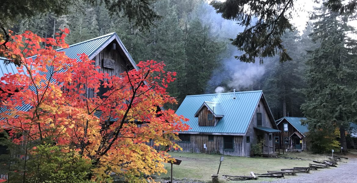
For the best Oregon hikes, check out Opal Creek and the surrounding wilderness area. Just two hours from Portland, 500-year-old forests line the creek and have begun to reclaim a nearly 100-year-old sawmill. Visit the Ancient Forest Center, a 501(c)(3) non-profit educational organization that owns and maintains the Depression-era mining town and rents cabins at Jawbone Flats. Hike an easy 4-mile loop along Opal Creek, or a longer 7-mile loop to scenic waterfall and opal pool lookouts. The surrounding wilderness area was only recognized in 1998. Yet this section of temperate rainforest makes up part of the largest temperate-zone rainforest on the planet. Step back in time as you wander the ancient forests of Opal Creek.

Opal Creek Information
Fees & Amenities
Day Use Fees, Passes
- $5 Day Use Fee (per day)
- Get a National Forest Recreation ePass (Oregon and Washington only) online at Discover Your Northwest
- Purchase Interagency passes or an annual Northwest Forest Pass for $30 online at the National Forest Service website
- You can also buy day passes at area Ranger Stations, outdoor stores, or the pay box at the Opal Creek Trailhead

Contacts, Closures, and Updates
Closures and Updates
- The U.S. Forest Service maintains the latest updates on closures, parking restrictions, and visitor information on its Detroit and Sweet Home Ranger Districts Special Regulations web page.
- Overuse, vandalism, and safety concerns led the Forest Service to restrict access to Forest Service Road 2209 past the Opal Creek Trailhead. This has created a safer and less crowded experience for visitors.
Fire and Camping Restrictions
- Campfires are prohibited within 200 feet of Forest Service Road 2209. That basically includes the entire length of the road, from the junction to the trailhead, and on to Jawbone Flats.
- Campfires are also prohibited within 200 feet of the Opal Creek and Kopetski trails.
- There are no federal campgrounds around Opal Creek, but limited dispersed camping is allowed. Visit the Detroit and Sweet Home Ranger Districts dispersed camping page for restrictions and regulations. For detailed information, including maps of affected areas, view or download the PDF document at the bottom of our post.
Forest Service Contact
- Supervisor’s Office Telephone: (541) 225-6300
- Address: 3106 Pierce Parkway Suite D, Springfield, OR 97477
Ancient Forest Center Contact
- Reserve cabins or inquire about the privately owned mining town at Jawbone Flats by contacting the Center’s non-profit Portland headquarters
- Telephone: (503) 892-2782
- Address: 721 NW 9th Avenue, Suite 236, Portland, OR 97209
Planning a trip soon? Click either of our banner links here to get discounted gear and car rentals to get you out into Oregon’s Opal Creek Wilderness. Our site is partly supported by affiliate partnerships; your purchases through our affiliate links help support our site and the development of even more great content!

Oregon Hikes: Getting to Opal Creek
Driving from Portland
Portland, Oregon to Opal Creek Trailhead
- 91.6 miles (147 km)
- Portland to Salem, Oregon: 45 miles (72 km)
- Salem to Mehama, Oregon: 25 miles (40 km)
- Mehama, Oregon to Trailhead: 21 miles (34 km)
Driving from Bend
Bend, Oregon to Opal Creek Trailhead
- 129 miles (208 km)
- Bend to Mehama, Oregon: 108 miles (174 km)
- Mehama, Oregon to Trailhead: 21 miles (34 km)
Parking, Accessibility, & Access
Forest Service Road 2209 to the Trailhead
Using the maps above, it’s pretty easy to get to Mehama, either driving West from Bend or East from Salem. Once you get to the flashing yellow light at Mehama, you’ll head North on the Little North Fork Road for just over 16 miles of mostly paved road. Then, at a fork in the road, take Forest Service Road 2209 another 4 miles to the trailhead. The road from the trailhead to Jawbone Flats and the Ancient Forest Center’s mining town is closed to non-resident traffic. But it’s a nice walk through the old-growth forest leading to the Opal Creek loops.

Parking at the Trailhead
Parking at the Opal Creek is restricted and enforced by the National Forest Service. Well-marked parking on the South side is open for parking up to 1/4 of a mile from the trailhead. You can also park at other designated trailheads at Henline Falls, Henline Mountain, and Nasty Rock. If you stop at the visitor kiosk at the junction of Forest Service Roads 2207 and 2209, you can only park a maximum of 15 minutes.

Getting Started at the Opal Creek Trailhead
Hiking Difficulty & Elevation
Elevation & Weather
- Trailhead Elevation: 1,950 feet (594m)
- Opal Creek Elevation: 2,200 feet (671m)
- Elevation of surrounding mountain peaks: 5,000 feet (1,524m)
- Be prepared for wet, rainy conditions. This wilderness area forms part of the largest temperate rain forest on the planet. It experiences more than 90 inches – almost 8 feet – of rain annually.
- The driest months in this area are late summer, July to September.
- Some snow possible in the winter. The trailhead and access to Opal Creek are open year-round.
Distances and Difficulty: Trailhead to Opal Creek Trail
- Hiking distance of unpaved Forest Service Road 2209: 2 miles (3.2 km); 4 miles (6.4 km) roundtrip.
- Hiking difficulty – Forest Service Road 2209: Easy, with maintained forest service road.
Distances and Difficulty: Opal Creek Trail
- Hiking distance of Opal Creek Loop: 2 miles total (3.2 km).
- Hiking difficulty – Opal Creek Loop: Easy to moderate, with some rocky and steep or slippery sections of trail.

The Start of the Trail
Little North Fork of the Santiam River
The first part of the hike to Opal Creek does not feel remote or secluded, because of the two-mile stretch of Forest Service Road 2209 leading to the Opal Creek loop and Jawbone Flats. A little past the trailhead and locked gate, you’ll cross a 60-foot high bridge over Gold Creek. From there, the road continues gradually up, winding around dramatic hillsides through scenic old-growth forests. This is the original road to the Depression-era mining town at Jawbone Flats. It also follows the Little North Fork of the Santiam River back toward Opal Creek.


Ancient Forests Along the Little North Fork of the Santiam River
This section of the hike is where you’ll see some of the oldest growth trees in the Opal Creek Wilderness. What the forest service road lacks in seclusion is more than made up for by the dense, towering foliage lining the river banks. After hiking a mile and a half, you’ll arrive at the Bertha E. Hewitt Memorial Grove, named for the wife of the mining company owner whose company built Jawbone Flats during the Great Depression. The cool, temperate rainforest climate only adds to the mystique. Mist rises from damp trees when the sun peeks through dense forest cover. And both flora and fauna are plentiful in this area. The Ancient Forest Center maintains a list on its website of hundreds of species of plant and animal life in the area.


Oregon Hikes: Depression-Era Machinery and Relics
The Historic Merten Mill
The Merten Mill, built in 1943, sits decomposing on the forest floor just two miles from the trailhead and right before the Opal Creek trail crosses the river. This unique, steam-powered mill used a repurposed steam engine from the U.S.S. Battleship Oregon to power its operations. Remains of the steam engine and machinery used to mill timber along the Little North Fork sit rusting away in a small clearing.


Merten Mill Operations
Despite its location in ancient, old-growth forests, the Merten Mill did not remove much of the surrounding timber. The operation removed logs from about 5 acres around the mill. When two lumber trucks tipped off the narrow, winding road, the mill closed. The mill sits close to the Little North Fork of the Santiam River. It’s also a short walk from Sawmill Falls, also known as Cascada de los Niños, where native Steelhead salmon end their winter run.


The Opal Creek Trail – Easy to Moderate Sections
Crossing the Creek
Just past the Merten Mill, you’ll come to another fork in the road. Continue straight for about a mile, an you’ll arrive at the Opal Creek Ancient Forest Center and Jawbone Flats (more on this below). For the scenic Opal Creek trail, though, take the 100-foot wooden bridge over the river to get to the Kopetski Loop. That will take you to the moderate-level hiking trail that follows the Little North Fork down to Opal Creek.


Hiking Through the Forest
Once you cross the wooden foot bridge, you’ll leave the forest service road and enter the more secluded, remote segment of the hike. Though the low-lying foliage is not as dense, the forest canopy seems thicker and darker, shading much of the forest floor. The trail follows the Little North Fork for about a mile before approaching the Opal Creek viewpoints and turquoise pools.


The Kopetski Loop – Views of the Pools
Getting to the Pools – Opal Creek Viewpoint
From the Kopetski Loop trail, a sign directs you 50 feet to the scenic Opal Creek canyon lookout. The overlook sits high above the clear, turquoise pools below. Though the high boulders are generally slippery from the temperate rainforest moisture, they provide unobstructed views of the Opal Pools. Bring your best lenses and a polarizing filter, because the views of this section of canyon are truly amazing.


Getting to the Waterfalls – Opal Creek Viewpoint
Downstream from the pools, you’ll find cascading waterfalls and moss-covered boulders to enjoy. This type of deep-green undergrowth is typical in this ecosystem, and an iconic part of Oregon and Washington wilderness areas from the Cascade range West. We spent most of our time in this area, because it’s the most secluded, picturesque part of the hike. Though campfires are prohibited within 200 feet of Opal Creek and the Kopetski Loop, evidence of dispersed campsites in this area abound. If you visit this area, please be responsible and pack out anything you bring with you. And if you’re camping overnight, look for less trafficked areas further away from the water’s edge.


More Opal Creek Waterfalls – Crossing the Creek
Once you’ve sat admiring the opal pools and mossy rocks surrounded by gently cascading waterfalls, there’s an easy path back to Jawbone Flats. Another log bridge passes high above the canyon, looking down to even more dramatic waterfalls at the start of the Opal Pools. Bring a tripod if you want to capture photos from the bridge; low light conditions make it difficult to capture a breathtaking shot without one!


The End of the Opal Creek Trail
Back Through the Forest
The trail beyond the Opal Pool bridge winds back around to Jawbone Flats through thinning forests along the valley floor. Taking this trail leads to the back side of the historic mining town. Here, you’ll begin to see evidence of the 100-year-old mining operations, including cut stone, discarded pilings, and other tell-tale signs of mineral exploration and extraction.


Back to Civilization – The Ancient Forest Center
Jawbone Flats includes nearly 30 well-preserved buildings built between 1929 and 1932 for mining operations. The historic mining town’s water wheel still produces electricity, and rusted vehicles from the 1930s sit among other disposed machinery and appliances on the outskirts of town. The land was donated to the Opal Creek Ancient Forest Center, a private, non-profit educational organization that manages the property today. Operating with a special use permit from the US Forest Service, the Center maintains the buildings, rents cabins to guests, provides educational workshops and classes, and runs a “Company Store” selling Opal Creek merchandise in the summertime.






Your photos are incredible. A lovely tribute to what looks like a fantastic hike. Pinning for when I get to this part of the world.
Thanks so much, Sharon! So many beautiful spots in Oregon and Washington, all along the Cascade Range to the coast. The high desert side of the mountains is pretty great too!
Opal creek looks so lovely. The waterfalls are gorgeous. A stunning hike.
I can’t believe I still haven’t been to Opal Creek! I have my Oregon/Washington park pass though, so maybe I can make it before it expires in August (I hope they extend it too!)
I would love to take every single one of these hikes. Thanks for all the background and historical information about each, and the images are absolutely STUNNING! The Opal Point Viewpoint looks like something out of a DREAM!
Amazing pictures! Just feel like going there! Thanks